In my first PD article I described our natural geographic situation so it would be easier for the reader to understand where we are, from a natural, geographic and climatic point of view. In the second article I tried to describe ”where we came from” i.e. the historical background of the place and region. In this third article I am still in observation mode with sectors and after that will follow zones. Again some parts of the article I wrote already in 2014-15 but now of course using the experience we have accumulated of the site until now. Surprisingly this is already the 7th summer we are here! And we have lived in our house for over 2 years!
Sectors
Sectors are directional forces or energy that come in from outside our site. Mapping sectors is an important part of the Permaculture design process. Sectors can be directional (sun, wind etc) and topographical (frost, flooding etc). Also risk of fire, crime, pollutants can be considered sectors as well as wildlife desire lines and corridors. (1)(2) Closely connected to the sector analysis is zone analysis which will follow in the next article. In analysing the site sectors and zones we are still strictly in observation mode.
The Sun sectors

The sun is directly or indirectly the source of practically all the energy that is available for us. Of the different forms of sun energy direct sunlight is the most obvious.
We all know that the sun rises from the east and sets to the west. However here in the north that is true only in March and September. In the winter the sun rises from south-east and sets south-west and in the summer rises from north-east and sets north-west. The sun elevation at midday also changes dramatically depending on time of year. In the summer the highest elevation is 53° but in mid winter only 6°. In our site it means that the mid-winter noon sun barely rises over the treetops in the south.


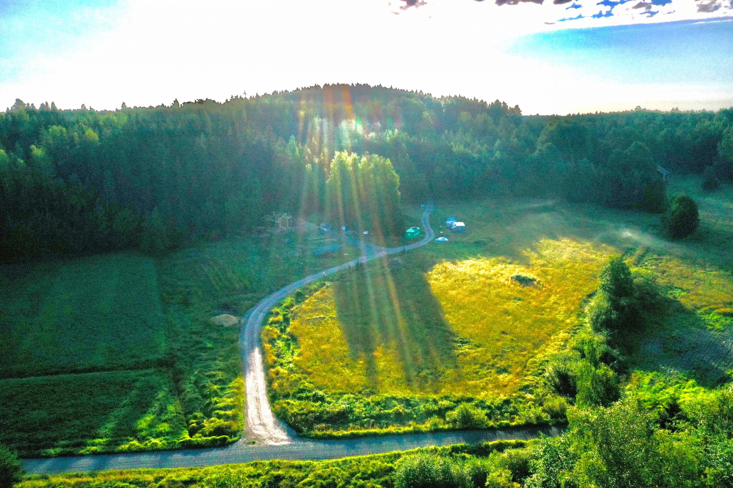
It is good to look at the sun sectors together with the contour lines of the site. We have a pretty steep hill with forest on the north-east side of our house and garden. It means that even in the summer sunlight hits the house only some 4-5 hours after sunrise – at 8.30 – 9.00 in the morning. However in the summer light is not a limiting factor – days are long and the sun elevation is high.
In mid winter there simply is very little light. We can see the sun in the south at noon behind or just barely over the tree tops.
We already know from experience that our solar panels produce relevant amounts of electricity from early February to end of October. In November, December and January they have almost no relevance for our electricity production.
Light and Noise
Apart from sunlight also artificial light sectors should be considered. This is relevant mainly in the winter when it is dark. The artificial light sectors map shows the situation in the winter.
The noise sectors are largely the same as the artificial lights sectors. The noise insulation of our house is very efficient but when outside the main noise source is the Karjalohja road with an occasional car, truck or tractor passing by. The road is very popular with motorists riding through Karjalohja on nice summer weekends. From the neighbours there can be the occasional noise of mowing the grass, chainsaw or tractor work.


The Wind Sectors


Wind is a form of indirect sun energy.
The main wind directions at our site are from the north-west to south-west sector. Average wind speed at 50m height is 5-6 m/s with winter’s slightly windier than summers. (Tuuliatlas) The site of the house and garden is well protected from northern and eastern winds but overall the field is susceptible to northern winds.
Water sectors


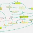
1.: Small trickle flowing through our forest (the origin is a small swamp to the east by the Karjalohja road) and into the ditch on our neighbours field and then back to our ditch. Normally dry in the summer. 2.: Ditch coming from south-east and flowing through our field and continuing into 3. Isosuo in the north and from there to Puujärvi. Another ditch runs along the road Varkalahdentie. These tend to dry out by July unless there are heavy rains. 4.:Groundwater runs down the slope into the field and when hitting the heavier clay soil there comes to the surface causing a quite large area 5. on the field to be wet. The same phenomenon keeps our garden 7. wet in the winter and into the spring. 6.: The fields have subsurface drainage piping which is visible in the aerial photo. 7.: A small ditch has been dug with shovel to direct the surface water out of the garden. 8.: Our well. 9.: Our willow sewage water system. 10. We can use water from the willow system for irrigating trees and bushes. The water is pumped from the opposite end compared to where the sewage water is pumped in. 11. Water collection from the roof of the house for use in the garden.
Desire lines
Below our desire lines represent our more or less regular movements at different levels. If regular is understood as at least monthly the furthest we go is the Helsinki area which is about one hours drive.


Other routes by foot and walking the dogs (violet lines). Our boat is at Rapakkolahti and in the summer we swim at Varkalahti.

The desire lines of other people are
- Karjalohjantie (east from us) is the road going south from Karjalohja to the Salo-Inkoo main road.
- On Varkalahdentie there are 2 permanently inhabited houses after us (to the north) and some 20 summer cottages. Traffic is scarce especially in the winter.
- Varkalahdentie is used for walking and jogging especially on summer weekends.

Fire
In Finland outside fire risk means risk of forest fire. However forest fires have not been a major problem in recent decades. Typically 500-1000 hectares of forest burns every year which can be considered a low number. Reasons include a good network of voluntary fire brigades, effective fire prevention including the forest fire warning system (Finnish Meteorological Institute) and forest road network. However it is acknowledged that global warming may in the future increase the risk of forest fire. (3)
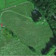
Our site and house is surrounded by forest from NW to SE. The forest immediately bordering our house is young deciduous wood that has low fire risk. The older spruce forest to the North of the house (and next to the sauna) has higher fire risk but relatively low risk of igniting. The highest risk forest type is dry pine forest which we don’t have on our property.
Fire risk is highest in the summer and non-existent in the winter due to high moisture. Firewood is not used in our house in the summer but we do occasionally barbecue in the summer and our sauna is heated with firewood. The chimney of the sauna is 3,5 metres so the smoke that exits the chimney has already cooled down sufficiently and doesn’t pose a risk.
First published 13.9.2020
Next article in PDA: Evaluation and site analysis 2: Zones
(1) Aranya. Permaculture design. A step by step guide. Permanent Publications. 2012. 191 pages. Page 62.
(2) Oregon State University: Introduction to Permaculture. https://open.oregonstate.education/permaculture/chapter/sectors/
(3) Linberg, H., Heikkilä, T., Vanha-Majamaa, I. 2011. Suomen metsien paloainekset – kohti parempaa tulen hallintaa. 104p (abstract in English)