This article is part of Erkki’s Permaculture Diploma Portfolio. Part of it was written already in 2015 when I first started writing our permaculture design. Of course a lot has happened after that and I have updated it to today’s situation.
In my first PD article I described our natural geographic situation so it would be easier for the reader to understand where we are from a natural, geographic and climatic point of view. In the second article I tried to describe “where we came from” i.e. the historical background of the place and region. In this third article the aim is to describe our site Iso-orvokkiniitty in order to understand our setting and thereby help understand where we can go from here.


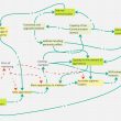
1. The site
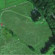
Iso-orvokkiniitty is situated in Karjalohja south of the main village in Kontolanniemi which reaches into Lake Puujärvi, one of the purest lakes in Southern Finland. All of Puujärvi is a Natura200 area. Puujärvi flows into Lake Lohja from the southern tip of the lake through a small stream. The property is not on the shore of the lake but has the traditional rights to the lake in terms of fishing and keeping a boat on the shore (vesioikeus, venevalkamaoikeus).
Iso-orvokkiniitty land area is approximately 12 hectares of which roughly half is field and half forest. The road Varkalahdentie runs through the property with some of the fields on the west side of the road.

Access to the property is from Varkalahdentie west from the main building site. There was no road (or any other infrastructure) on the property when we bought it in 2014. The road was built over the field to the building site in February 2016. Before that it was possible to drive over the ditch and the field by car in the summer if it wasn’t too wet. When walking to the village we use a path going directly east to the Karjalohja road. Varkalahdentie is connected by a track to Kontolantie so by bike or walking it is possible to take also that route to the village.
1.1. Fields
Field boundaries

At the south-east side of the field is a small wood behind which is a neighbouring house. The boundary to the south-west is a main ditch (valtaoja) which has not been maintained and is therefore growing willow and grey alder and perennial shrubs. On the other side of the ditch is a similar field which we bought a little later and which is organically cultivated by organic farmer MR (permanent lay; clover-hay-etc mix).
The west boundary is a short part of Varkalahdentie road. On the other side is a tree-covered wetland area ‘Pikkusuo’ which is connected to lake Puujärvi through a larger wetland area to the north. The field on the other side of Varkalahdentie is also ours but leased out to MR. The north boundary is a small open ditch. The field to the north is owned by our neighbour JN who is leasing the field to an other organic farmer ML. It is cultivated in a grain – lay crop rotation.
Bordering our forest is a ditch which is running the water from the forest across the fields to the wetland area. The boundary between field and forest is growing mainly Willows, Aspen, Grey Alder and Birch.
On the NE side at the highest point of the field there is a small forest ”island”.
The fields have been cultivated by “MR” for the last roughly 20 years together with the other fields nearby – therefore the field was already certified organic when we bought it. The farmer has only cultivated permanent clover-hay for his animals and maintenance of the lay has been only seeding as necessary. The contract was still in place in 2014 and we have continued it for the time being apart from the 1,5 ha closest to our house (inside the blue area on the map) but even there he harvests the hay for the time being. That field slopes slightly to the west and is wet from the NE corner because of water flowing from the forest and in the lower parts in the west. The drainage is not in good condition and the field can be very wet in the rainy seasons and when snow melts in the spring. Groundwater levels are high.
The wetland “Pikkusuo” on the west side of the road keeps the water level high also on the field. The soil is clay with relatively low pH (5,8-5,9) and low nutrient content typical to Finnish mineral soils. The flora is a mix of perennial leguminous plants, grasses and others (see Table xx). The yearly removal of the biomass by the farmer is transforming the fields into a flower meadow. In the spring it is yellow with blooming dandelion. The yellowness continues with buttercups (Ranunculus sp.) and meadow vetchling (Lathyrus pratensis). The flora on the edges is more diverse. On the east side of the field there is a small “island” of trees (5.) that divides the field into two parts and offers a natural shelter (that’s where we built our summer kitchen). Also all other fields closeby are farmed organically either by MR or the other organic farmer ML.
1.2. Forest


white flowers will be Lily of the Valley.
The two pieces of land to the SE with building rights are mainly young forest especially on the lower parts bordering the field. The area has been logged approximately 25 years ago (late 1990’s) and cleared after that twice. The young trees that have been cleared have been left on the forest bed. In 2014 we cleaned most of it into piles and used some in our Hügelkultur beds. The fauna consists of trees: mainly birch, aspen (haapa), hazelnuts, rowan and Grey alder (harmaaleppä). The land rises about 20 m from the field to the eastern side the steepest rocky part being presumably an old shore of the Ancylos-lake after the ice-age (60 metres above current sea level). In places the granite rock (peruskallio) is also visible. Above on the steeper part trees include also pine and spruce. The undercover of the young forest is dominated by bracken (sananjalka, Pteridium aquilinum) and lady fern (hiirenporras; Athyrium filix-femina). In the spring there is blue anemone (Hepatica nobles) and white anemone (Anemone nemorosa) and lily of the valley (Convallaria majalis) blooming one after the other.
Spruce forest and hazelnuts

The 3 ha forest on the north is in the lower SW side old spruce trees with very little undercover. On the north-east side the forest is younger and mixed. There is a very small trickle flowing through the property from east to west. In the summer it dries out. On the north side of the trickle there is roughly 0,4 ha of old wild hazelnut which however is becoming covered by other bigger trees, most notably birch, pine, alder, aspen and shadowed by big spruce in the south. The undercover includes blue anemone (sinivuokko) in the spring but in the summer there is practically no undercover due to heavy shade of the hazel. The north end is a mixed spruce dominated forest including also pine and birch with undercover of blueberries. Also some Black elder (mustaselja) here and there.
Going clock-wise the forest borders to our field to the south-west with a narrow ditch which is mostly growing young trees that shade the inside of the forest. The situation is similar on the border to JN’s field but the ditch belongs to JN. Where the property border turns from the ditch north into the forest the border goes very close to JN’s house and is marked with fence poles until the border point. Turning north-east the bordering forest is young uncleared forest-bush belonging to JN. Close behind this part of JN property is the PX family property. The north-east long straight border is against Immula Manor forest which has been clear-logged maybe around 2005. It has been planted with pine and spruce and grew also densely with naturally seeded birch and hazelnut but those were cleared in 2019. On the other side of the clear-logged area is a managed mixed forest and to the north some bare rock area. Where the border turns south the Immula Manor clearcut area ends and turns into a mixed forest. Then the neighbour changes to Honkamäki on the east and on the south-side to Seppä. Toward Honkamäki is a stone fence and toward Seppä a ditch in the forest.

Trickle
A small trickle (about 50 cm wide and dry in the summer (”noro” in Finnish) runs from a small marsh on the other side of the Immula Manor clear-logged forest close to the Karjalohja road. It ”flows” through our forest to about the middle of the ditch between our forest and JN field. In the forest the ditch forms a border between the old dark spruce forest and the hazelnuts grove. Lady fern grows along the trickle and dear frequent the upper muddier part where the trickle enters our property.
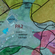
In 2015 we bought additional land (within the red lines in the first map) which is mostly field and has similar management history as the fields closest to our house. The piece to the north has some wetland forest connected to it and the piece to the south has some young deciduous forest (poplar, birch, alder) on the south side which apparently has been field earlier.
1.3. Contour lines

1.4. Development of the site
(Edit 9.6.2021: aerial photos 1937 & 1996)
In May 2021 Maanmittaushallitus (National Land Survey) made historical aerial photograph maps available on Paikkatietoikkuna. At our site maps are available from 1937 and 1996. Hopefully maps from 1951 will also become available later.


We have been active on the site since June 2014 so quite some changes have happened already as shown in the following photos. We started with our first permaculture designs right in the beginning so justification for different actions can be given later in this permaculture design.


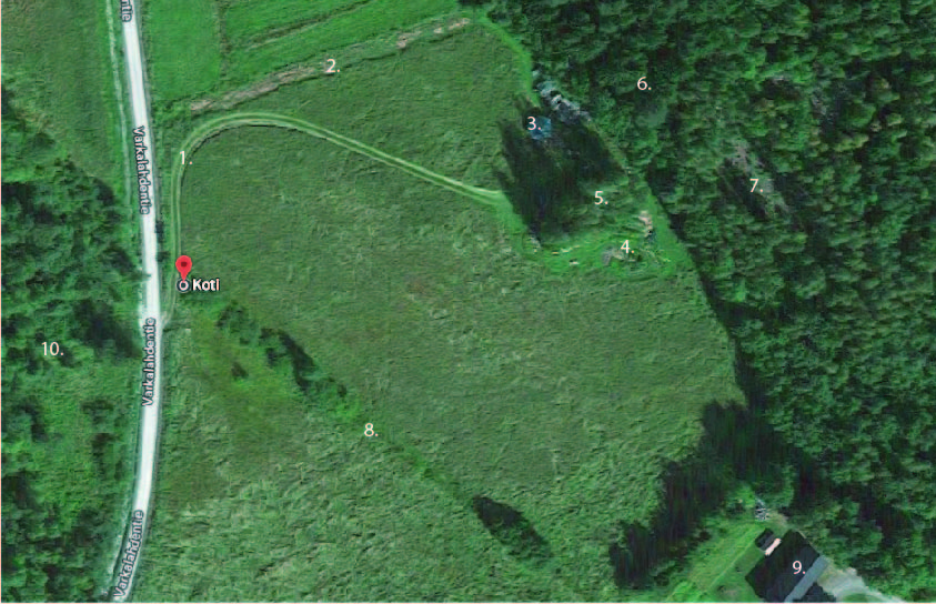
1. The track is a result of driving by car over the ditch from Varkalahdentie to the side of the “island”.
2. We have started planting trees for windbreak in hay mulch made with spoiled hay big-bales.
3. We parked our caravan on the north side of the forest island (in the shadow) and stayed there the whole summer of 2014 and early 2015. Under the tarp is a truckload of straw bales and closer to the forest piles of old stocks we collected from a few buildings elsewhere.
4. We started our garden with Hüglekultur raised beds. To the left the first beehives.
5. In the “island” evolved our summer kitchen.
6. The first building was our dry toilet made of the old stocks inside the old-growth spruce forest.
7. We started to clear the young birch forest for our house.
8. The ditch between our fields growing Salix sp. and Populus tremulus.
9. Our closest neighbour.
10. Wetland “Pikkusuo” to the west.


1. The 250m long road to the house was built in February 2016. The top soil was lifted to the south-west side of the road and replaced with a textile and 30 cm of gravel. Berry bushes and trees were later planted on the slightly elevated top soil bed along the road.
2. Some more trees have been planted for the wind-break.
3. Some more material has accumulated including our children’s wooden sailing boat project.
4. The garden is expanding and also here bushes and trees have been planted and more beehives added.
5. Now the summer kitchen has a terasse and a roof.
6. Dry toilet.
7. The house was started by digging the foundation in July 2016 and built up to the roof before starting with straw bales and clay work under the roof in November 2016.
8. The grass is harvested for ensilage and packed in white plastic big bales by the farmer.
9. Our neighbours old barn.
10. The Pikkusuo wetland.
11. Our second closest neighbour,
12. This is part of our property with separate building rights. For the time being no plans to build. It is young deciduous forest (open logged in early 1990’s) mainly consisting of Populus tremulus, Salix sp., rowan and birch. Towards our house birch dominates.
13. A warehouse tent we installed for building material and extra strawbales. The other end crashed under snow the second winter.
14. A sea container we bought for stuff from our apartment and office in Espoo when we sold them.
15. The source of the clay for our building.
16. Here we dug a traditional well.


1. More trees and bushes have been planted along the road.
2. More trees have been planted for the wind-break. The willow water purification system (8x30m) has been finalised and covered with saw dust. Piles of saw dust and bark shavings to the left are used as mulch in planting trees.
3. Soil from digging the willow system beside it. The sailing boat is still there.
4. The garden and apiary still there.
7. We moved in the house in summer 2018.
8. We’re planting hazel nut varieties, Sweet Rowan etc along the main ditch.
10. The Pikkusuo wetland.
13. The warehouse tent collapsed totally in winter 2018-19 and we took it down.
14. The sea container is still there,
15. The source of the clay for our building.


2. Boundaries
Some boundaries were mentioned above. Obvious boundaries are
- boundaries of the property
- boundaries between field and forest
- boundaries between fields (ditches)
- roads
- boundaries in forest because of different logging history or difference in natural conditions
Climatic boundaries relate to
- what plants can be cultivated
- what kind of buildings and sheds are required for different functions
- what resources are naturally available at different seasons
I will analyse boundaries in relation to zones and sectors in the next article.
People
Erkki & Marja and family

Erkki and Marja bought the property in 2014, started building the house in 2016 and moved in the house in 2018. For the time being we are the only ones living permanently here. All together we have 6 children, the youngest we have together and she is already in her twenties. All the children have moved on their own and we have now 3 grand children with 4th on the way. When we first bought the site we arranged a meeting with our children to understand what wishes each might have.
Occupations and skills
Erkki is an Agronomist (M.Sc.). He has been involved in organic farming and food his whole adult life and has worked in organic food export since the late 1990’s. Marja has a Bachelors degree in Agronomy and practical experience in animal husbandry and has worked in the organic food business with Erkki. She has also a M.Sc. in Philosophy and recently got her Bachelors degree in Hortonomy and Landscape Design which she wanted as a formal degree to support Permaculture Design. She has started to do Permaculture inspired Garden design as a new business. Both Erkki and Marja are theoretically well equipped to run a permaculture farm but practical experience must be developed.
Local like-minded people
Karjalohja is not the typical rural (ex) municipality because of a strong influence of ”outsiders” that have moved to Karjalohja over the last few decades. Many of these have moved to Karjalohja because of the Steiner school which was founded in 1984. Therefore there is a rather large number of more-or-less ”alternative minded” people in the area. The relationship between the original and the outsiders has become more relaxed over time. Karjalohja also has a very high proportion of organic farmers with up to 40% of the field-area in the ex-municipality being certified organic (Finnish national average 13% in 2019). Several people in the community are inspired by permaculture.
Needs
The purpose of Marja and Erkki is to live at Iso-orvokkiniitty and develop it into permaculture inspired modern homesteading with relative self sufficiency. That includes a house built on ecological natural building principles, energy self-sufficiency and developing their own food production. The site should generate some income over the years but Erkki will also continue to run his business in organic food export for the time being to ensure sufficient income levels to cover the house loan and site development. On a 10 year perspective there should be sufficient income from the site to cover what is needed money-wise after the house loan has been paid.
Secondly the aim is to develop Iso-orvokkiniitty into an open permaculture centre and LAND site to promote sustainable lifestyle practises and permaculture.
Neighbours
Neighbours bordering the property are JN to the north-west, Honkamäki to the south-east and Seppä to the south. The clear-logged forest to the north-east belongs to Immula Manor which got new owners in 2019 and now is under heavy renovation. Bordering JN to the north is PX with biodynamic homesteading.
3. Resources
3.1. On-site
Water catchment
In Finland precipitation is higher than evaporation. Therefore drying cultivated land by means of drainage has always been the main concern of a farmer or gardener in Finland. On the other hand the period from spring to late summer can often be too dry from the point of view of cultivation and preserving water for the needs of cultivation is an issue.
To start with the water management on the site was poor.
- The ditches on the upper side of the field (piirioja) is in bad condition due to overgrowth in the ditch. However the amount of surface water entering the field from the forest is low and this should not be a major problem.
- The sub-soil drainage in the field is in bad condition at least in the SE upper corner of the field where the field is clearly wet although it dries sufficiently for the hay harvest. Water from the forest uphill from the field keeps the SE field wet in the spring and depending on raininess at other times.
- The lower western part of the field is wet although it also dries sufficiently for the hay harvest. However vegetation indicates that this part of the field is more or less permanently wet.
- The main ditch on the west side is partly overgrown by trees.
- The water level in wetland area on the other side of the road is relatively high limiting the main ditches ability to take the water out.
- The trickle going through the forest has very limited amount of water and has dried every summer so far (2014-20). It flows to the ditch on JN’s field on the north side and to the ditch between our site and JN’s field.
- A traditional well (rengaskaivo) was dug in 2015 in SE field corner close to the new road to provide for clean household water. A sorcerer had indicated a well-place on the south side of the ”forest-island” that should have good quality water at 3 meters depth. An other more obvious water-vein was the SE of the field indicated above as a wet point on the field. Supposedly the water quality is better on the first mentioned place.
Opportunities regarding water catchment:
- Several ponds can be dug in the field, the biggest one on the wet area on the W-side of the field. A small pond was started in 2015 when clay was dug for the house building project. Eventually the big pond can be used for irrigation but also for swimming and for developing on-site biodiversity.
- A water catchment system will be connected to the house’s roof. This water could be used in the garden. Surplus could be used in a pond dug below the house from where it can trickle to the upper pond on the field.
- A pond could be dug on the E-side of the forest where the trickle enters the site. The main motivation would be biodiversity development (water for animals) but water could also be used in the hazelnut grove for needs of irrigation or mushroom cultivation if it is sufficiently accumulated. The pond would have to be dug manually as tractors can not enter.
Soil
Finnish soils are young having been formed after the last ice-age (see previous article). The field is sandy clay or clay soil (hietasavi) becoming heavier towards the lower wetter part of the field. The forest is loam (hiue). The nutrient content of the soils is low. The only nutrients that are at recommended levels are Magnesium and Calcium in the field. The Phosphorus is very low everywhere and Potassium is low. pH is low in the fields and very low in the forest. Karjalohja should have Calcium rich soils which partly explain hazelnut groves in the area but the analysis of the soil of the hazelnut grove does not support this.
- Most cultivated plants benefit of pH values of over 6. Higher pH increases microbiological activity in the soil and thereby solubility of existing nutrients.
- Potassium should be available in clay-soils but the analysis indicates that it is currently not in a soluble form. The situation could be enhanced by increasing pH and microbiological activity in the soil.
- The Phosphorus content of Finnish mineral soils is naturally poor. Therefore it is doubtful if even higher pH and more active microbiology would result in sufficient P-levels in the soil. On the other hand especially mychorizal fungi is beneficial for making P soluble.
- Presumably also micronutrient levels are low.
Opportunities regarding the soil:
- Increase pH by use of Chalk or Dolomite. If clean wood ash is available it could also be beneficial. Ash would also increase micronutrient availability. If done in bigger scale the chalk should be spread by machine before ploughing the field. In smaller scale egg-chalk can be used.
- To increase availability of P, rock-phosphate could be used. Also meat-bone meal which is available for organic farming has high content of P.
- The above could be applied overall to the field or specifically when preparing raised beds (hügelkultur) or planting perennials. In the forest these can/should be applied only specifically when doing plantings.
- MR, who leases our field has animals on his organic farm (horses, sheep, bison). He has provided us with a tractor load of manure every year.
- Nitrogen-fixing plants can accumulate nitrogen in the soil. On the field this means leguminous plants but in forest-systems also nitrogen fixing trees. Naturally this means grey alder (harmaaleppä). Other nitrogen fixing trees are: black alder (Alnus glutinosa – tervaleppä), sea buckthorn and others.
- Deep rooted plants are important for soil structure and for bringing nutrients up from deeper soil layers so they can become available for other plants.
- Mulching is an important way of caring for soil by avoiding bare soil, feeding soil micro-organisms and transferring nutrients from one place to an other.
- Hügel-kultur raised beds involves using wood to build raised beds thus bringing nutrients from the forest to the garden. Raised beds can also be built for forest farming.
- Enhancing the growth of fungi benefits soil fertility. This can be either by means of supporting mychorizal fungi growth or saprophytic fungi.
- We want to avoid ploughing for several reasons: ploughing can be detrimental to soil microbiology by turning fresh biomass under into potentially anaerobic conditions and destroying earth worms and fungal mycelium. Additionally ploughing involves high energy and machine power consumption. We do not plan to have a tractor.
Aspect
The property is mainly facing west and south-west. The field is somewhat protected from the west by trees and bushes growing in the main ditch. The field has no windbreak to the north. The hazelnut grove is overgrown with other trees and shaded from the SW and S by tall spruce. The building site for the house is inside the young birch forest and therefor protected from winds from all sides. The highest point on the property is behind the house where the windmill was built. Sectors will be analysed in more detail in the next article.
Available utilities
Originally there were no utilities on the property.
Energy
The main potential sources of energy on the site are wood, solar and wind.
Average forest growth in South Finland is 5 m3 wood per year per hectare and in southern Finland it can be up to 6,6 m3 per hectare. The forest on the site is in different stages of development and has different compositions of tree species but all are healthy so we can presume a net growth of at least 30 m3 of wood per year from the site. Heating the house is estimated to consume 6-8 m3/year including heating hot water in the winter. Heating the sauna could be an other 3-5 m3 year depending on usage. Therefore roughly one third (10 m3) of the yearly growth on the site would be needed for heating.
Solar energy is available through spring, summer and autumn but very limited in the winter. Solar panels can be used for electricity and collectors for heating water. Panels will be installed on the house roof and later on the roofs of other buildings on the site.
As solar power is very limited in the winter months it is necessary to install also wind power. Wind speeds in the area are in average 5,5 m/s in 50 m height and the main wind directions are NW to SW with most winds from SW. In the winter months October to March the average winds speeds are 5,8 to 6.9 m/s at 50 m height. Installing a 3 kW wind turbine at 25 meters height should cover the energy needs in the house in the winter. Combined with the solar panels it means that there will be excess electricity in the summer months.
3.2. Off-site
The most important off-site resource for the time being is income from outside Iso-orvokkiniitty which enables us to buy resources and pay the house loan. Apart from that the following off-site resources have been identified:
Forest and woods nearby
Based on Finnish ”everyman’ rights we can pick wild berries and mushroom in the forests and woods in the region.
Puujärvi lake
We have the right to keep a boat on the Puujärvi lake shore about 1 km north from our site. We also have fishing rights in the lake which enables us to catch fish. The lake is also important for swimming and other recreation also in the winter.
Organic farmers in vicinity
Manure is available from MR, the organic farmer leasing our field.
Ali-alha organic farm grows strawberries, other cultivated berries, potatoes and grain (f.ex. organic rye for baking rye bread).
People in Karjalohja
As explained in the article about Karjalohja, there is a lot of “alternative minded” people in Karjalohja. Linked to that are the Steiner school in Sammatti, a Steiner kindergarten, the village house Kehrä with different activities and Rukki cooperative
Karjalohja village services
Karjalohja village has a service station, supermarket and pharmacy. Lohja spa-hotel and local airbnb can provide for accommodation.
Tammisto arboretum
Tammisto arboretum in Karjalohja is a famous arboretum founded in the early 20th century with a wide range of trees from the northern hemisphere.
This article is part of my Permaculture Diploma Portfolio. I might improve and edit the article after its original publishing. That will be marked below.
In the next article I will go into sector analysis of the site followed by zones. Keep posted!
Previous article: 60 Degrees North, 23 East
Next article: EVALUATION AND SITE ANALYSIS 1: SECTORS
Published 31.7.2020
- Edit 9.6.2021 (add historical aerial maps 1937 & 1996)
- Edit 4.7.2021 (add last google maps from June 2020)
- Edit 22.1.2022 (add general maps in the beginning of the article, some minor corrections)